
AN OPPORTUNITY FOR PLACEMAKING
WORDS & IMAGES Amanda Tisdall
4th Year

Elusive spaces, such as abandoned lots, degrading post-industrial sites, or areas under bridges, stand in contrast to the methodically planned, readily definable spaces that make up the majority of the city. They seem almost like mistakes that were never erased from the landscape. Because of their absence of a designated use or order, “such spaces hold spatial and programmatic potential for realization of what is thus far unseen or unimagined, both in the eyes of cities, economic and development forces, as well as in those of its users” (Sola-Morales, 1995). Similarly, the implied lack of regulation and proprietorship that both causes and results from exclusion from composed urban fabric, brings freedom and opportunity for engagement on the part of the user. This freedom is part of what makes “genuine public space, and an open city” (Sola-Morales, 1995).

“Users of public spaces should be given the opportunity to activate themselves as agents of change in the city fabric” (Ruskeepaa, 2010). Possibilities to alter function, materials, or configuration of urban public space, the opportunity to imagine and introduce an alternative usership, and the potential to temporarily feel a sense of proprietorship in the public realm. Flexible urban areas that are yet to have their full spatial potential exploited in the form of full development that are able to respond to the city dweller are few and far between. These places are the last personalizable public spaces.

FUTURE PROTECTION
WORDS & IMAGES Olivia Koch
4th Year
The intensification of agricultural land use has occurred as farmers have responded to economic consumer and exporter demands. With the advancing urban environment, intensification of farmland and loss of habitat, the wide range of biodiversity, community and cultural connections we once had in the rural landscape are disappearing rapidly.

The intention of the project was to establish strategies and frameworks, by way of species regenerative projects that help mitigate the impacts that rural processes have on waterways and help future proof farming practices through the expected urban and rural growth.
Analysing the farmed, cultural and environmental aspects of a dairy farm gave vital information on the type of design moves that needed to be made in order to reconnect the farm with the community and significant cultural characteristics. Integrating these elements into the farm landscape through restoration projects established a new sense of place for the community and cultural aspects within the rural sector.

MINIMISE MAXIMISE
WORDS & IMAGES Andrew Priestley
4th Year

This research project demonstrates alternative strategies in the way golf courses are designed. These alternatives aim to minimise negative impacts on the environment and maximise biodiversity.
The project has focused in the first instance on identifying the unique ecological aspects of a particular site. Having established these potentials and problems the focus is then turned to the integration of a design that works with the existing landscape to achieve these objectives; ecology (which relates to maximizing biodiversity and minimizing negative impacts), amenity and finally playability.

Through the process of design and balancing the three objectives, there is a greater focus on understanding the existing conditions of the landscape as opposed to a normative approach whereby generic strategies are imposed. The potential, which could manifest in any environment, is a golf course, which is truly unique and one that could not appear elsewhere.
All the perspectives have a poetic sense in the way they capture the typology of this golf course and the outcomes it has aimed to achieve. They demonstrate the key strategies on each individual hole in a way that the viewer can imagine being in the moment, playing that shot or that hole.

QUAY NODES
WORDS & IMAGES Dave Parker
4th Year
Throughout waterfront cities worldwide, there is a growing sense of disconnection between waterfront and city, leaving the waterfront as an underutilised space. This project focuses on Quay Street – the disconnecting space that lies between Auckland city and it’s waterfront.

Auckland’s waterfront is comprised of local nodes, each having a unique character and sense of place. The nodes with the strongest senses of place utilise and emphasise the surrounding heritage and character through the retention of archaeological elements, patterns and materiality.

Three nodes along Quay Street were focused on in more detail, as their unique characteristics were not fully utilised or emphasised. The consistent goal for each space was to create a public connection with the water, its fluctuations and the maritime uses that inhabit Auckland’s waterfront. Conveying this connection, poles float on sea level and protrude through the fixed spaces above to portray the fluctuations of tidal levels, giving a sense of connection to the water below.
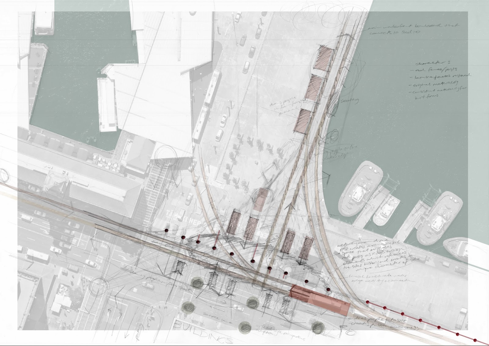
By capitalising on the historic factors and the character specific to these local sites, this begins to create a unique sense of place.
TAKAPUNA'S SUBURBAN WATERFRONT
WORDS & IMAGES Blair Clinch
4th Year

The suburb of Takapuna and the iconic Takapuna beach share the same context, however their sense of place is disparate from each other.
By investigating, analysing and improving the broad scale factors that influence both the suburban centre and the beach such as public transport and coastal processes, it formed opportunities for public space expansion and a shift to pedestrian prioritisation which allowed for the manipulation of site scale factors including slope, constructed elements and material use to further improve the broader scale connections as well as the pedestrian and public space connection between the suburb of Takapuna and Takapuna beach.

This public space expansion and pedestrian prioritisation draws the pedestrian and public characteristics of Takapuna beach into Takapuna suburb, whilst scored concrete, dune planting and emphasising of view shafts in Takapuna suburb further emphasise Takapuna’s coastal context.

Through investigating how to connect Takapuna beach to the growing suburb of Takapuna it lead to the protection and improvement of the unique characteristics of both Takapuna suburb and Takapuna beach. Through extending these characteristics between the suburb and the beach it did not completely alter either’s sense of place, just further enhanced them through emphasising the outstanding characters of each entity. Conveying the sense of one ‘place’ directly contributes, and is a part of, the sense of another local ‘place’, suggesting that all ‘places’ are linked in some way, and those factors that link them are of the highest priority for landscape architects to analyse and improve through landscape architectural implementation.
THE PARALLELS OF PARKING
WORDS + IMAGES John Allan
4th Year
 |
| Wakefield St Carpark is transformed into a student commons, including space for food production. |
This research investigates the
potentials for expanding the open space of a city by utilising the
infrastructure currently dedicated to parking. Based on the premise that the
limits of key resources, such as oil, will be reached within the current
century, parking and other automobile infrastructure will inevitably become
redundant within the same timescale. Added to the longterm implications of this
premise, there are various short to medium term gains to be had by removing
parking from the central city, as identified by urban designer Jan Gehl and
planner Donald Shoup.
Framing this research is the
question:
How can parking infrastructure be utilised as a public space
network?
This investigation reveals that
simple behaviour changes such as living, working and recreating in the same
locality are important steps to helping people stay out of their cars. Further
to this, the localisation concept can be expanding to include producing as many
goods locally as possible in a bid to live within the bounds of a particular
bioregion.
With these
various theories as a backdrop, this research proposes a robust, connected
network of walkable streets and public open spaces throughout Auckland’s CBD. Urban Agriculture features heavily in this scheme, throughout 3 separate interventions at former parking sites in key locations.
Expanding on the visionary ideas from the Auckland Plan and City Centre Master
Plan (The Green Link, The Laneway Circuit) and partnered with the power of an
improving public transport system (The City Rail Link) a more walkable Auckland
is achievable.
 |
| St Matthews Church Carpark is transformed into a market and events space with urban agriculture rooftop. |